
This page is dedicated to a collection of linux programs developped to achieve fast, high quality, and semi-automatized mesh generation
Automatic mesh generations aims to maintain human intervention in mesh processing at the lowest possible level. Basics of good meshing are:
- resolution fitting (ocean) dynamics constraints, along boundaries as well as in mesh interior
- resolution fitting geometrical constraints such as:
- details level (locally) desired along shorelines
- adequately sampled straits and channels, if any
- numerically acceptable aspect ratio
- etc…
Mesh boundaries : coastal boundary automatic sampling
In unstructured mesh generation process, coastal shoreline appropriate sampling is a critical and often painful step, especially in some regions showing highly chaotic shorelines (such as the Norvegian Fjords area). The mesh limit creation software aims to automatically extract shorelines in a given frame, filter details to a level consistent with the final mesh resolution, possibly aggregating close islands clusters, eliminate unnecessary limits (inland lakes, etc…), and produce the consequent mesh limits file (built as closed polygons). It is based on a similar algorithm described in the shorelines section.

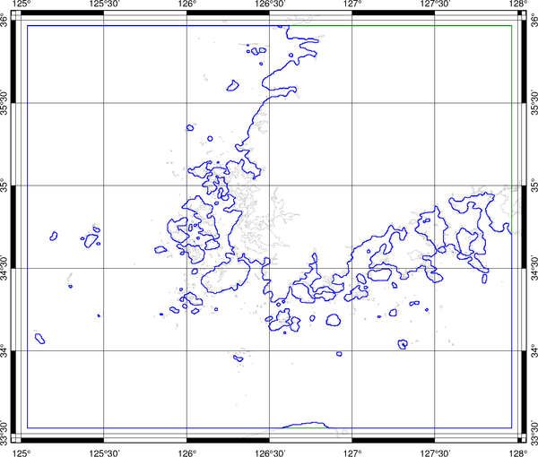
Mesh limits construction example (South Korea)
GSHHS original shorelines (gray lines), extracting frame (green lines), mesh limits (blue lines)
Mesh generation :
The mesh generation program needs as input:
- a mesh limits file (closed polygons, sampled or not at the desired resolution)
- a bathymetry file
- a mesh resolution criteria file containing instructions for:
- setting mesh interior resolution
- setting open and rigid boundaries resolution

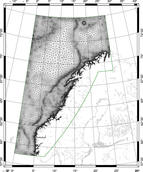
Automatic mesh generation example: Norvegian Sea
Inputs are raw shorelines (GSHHS), bathymetry (gridone, GEBCO), meshing area definition polygon (green) and mesh resolution criteria file. No manual edition needed, automatic processing needs about 180 s CPU.
Mesh upgrade :
The mesh program allows for modifying an existing mesh, entirely or in specified areas. It needs as input:
- an existing mesh
- a mesh resolution criteria file
- optionally a polygon file defining region of modifications